Topography of Power
By Rainer Atzbach and Stina Højrup, Aarhus University

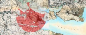
The castle mound “Bygholm” close to Horsens. Its large viewshed (red) is covering the whole surroundings (Source: Høje Målebordskort og Danmarks digitale Højdemodel, Styrelse for Dataforsyning og Effektivisering).
This ongoing research project is a cooperation between the Department of Archaeology and Heritage Studies at Aarhus University, the Chair for Protohistory, Medieval- and Modern Archaeology at Christian-Albrecht-University of Kiel and Moesgård Museum, Aarhus.
The aim is to discover the organization of lordship in medieval and post-medieval Denmark by means of a spatial approach. Aristocratic landscape surrounding castles is understood as a space formed by human interaction with a physical setting. The point of departure is Lefebvre’s idea about the production of space (1974): Topography is structured by dynamic elements as human actors, their temporal trails and simple housing on the one side, but also by static elements constructed for centuries as castles, churches and monasteries. The project will interrogate archaeological contexts, written sources and geographical data as terrain contour, distances, administrative borders and historical roads in order to gain a new access to medieval lordship in space.

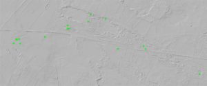
Fan af trails between a chain of grave mounds (green) close to Varming, Esbjerg Kommune.
The current road is identical with the historic one on the Royal Academy of Science’s mapping (Source: Danmarks digitale Højdemodel, Styrelse for Dataforsyning og Effektivisering)
First results have shown a correlation between a castle’s builder and its visibility: Royal or ducal castles tend to be central and visible, whereas fortifications of rich peasants, knights or pages (væbner) hide in wet lowlands. A surprising outcome is that all castles seem to seek the vicinity of shire borders and seem to avoid eye-contact to neighbouring seats. Ongoing study scrutinizes the position of castles in the historical road network using Sophus Müller’s (1904) and Thorsten Lemm’s (2013) model that chains of grave mounds acted as landmarks for trails. Comparison between these chains and the earliest Danish cartography by Royal Academy of Science in the late 18th century provides a proxy to medieval roads. Moreover, the project will explore, in how far material culture on castles and manor houses reflects kinship of European nobility.
Atzbach, Rainer. Die Lage Dänischer Burgen und Gutshöfe. Zwischen weithin sichtbarer Landmarke und wettergeschütztem Adelssitz, Château Gaillard 28, 2018, 15-25.
Atzbach,R., Jørgen H. Fenger and Kasper T. Høgsberg, Castle and Landscape in Denmark. A Topography of Power, Zeitschrift für Archäologie des Mittelalters 45, 2018, 193-214.
Atzbach, R./Hansen, Philip H.W.B., Neue Forschungen zu Burg Brink in Ballum-Østerende, Kommune Tønder, Arkæologi i Slesvig 2018 (2019) in press.
Fenger, J. H., A Data Analysis of the Construction of Medieval Castles in the Former Counties of Thisted and Hjørring (Denmark), in: Magnussen, S. /Kossack, D. (eds.), Castles as European Phenomena. Kieler Werkstücke A52. Berlin: Lang 2018, 169-176.
Lemm, Thorsten. Die Frühmittelalterlichen Ringwälle im westlichen und mittleren Holstein. Textband. Germany, Wachholtz Verlag, Neumünster/Hamburg. 2013, esp. pp 293-420.
Müller, Sophus. Vei og Bygd I Sten- og Bronzealderen. In Nordisk Oldkyndighed og Histori 1904, pp. 1-64.
More information, please contact Rainer Atzbach: rainer.atzbach@cas.au.dk